Bayerische Voralpen: For all the Adventure in the World
Bayerische Voralpen or the Bavarian Prealps is a part of the Northern Limestone Alps located in Southern Germany. It is situated between Rosenheim and Garmisch-Partenkirchen.
If you were to broadly identify them on a map, then the Bayerische Voralpen is precisely located between the river Loisach, which will be on the western side and the river inn which falls on the eastern side. The total length of the mountain range is about 80 kilometres or 50 miles and its width ranges between 12 and 19 miles or between 20 and 30 kilometres.
It is also important to understand that the term – Bayerische Voralpen does not quite has a political definitiveness as such. Geographically speaking, a few sections of the pre-alpine such as, Hinteres Sonnwendjoch, fall in the region of Tyrol, Austria.
More often than not one tends to include them within the Bavarian Alps or the Bavarian Alpine Foreland, but that is simply a misconception. You can understand by the following, the Bavarian Alps are almost entirely located within the geographic confines of Bavaria itself. On the other hand, in the case of the pre-alps, they are limited to a few sections of the neighbouring region.
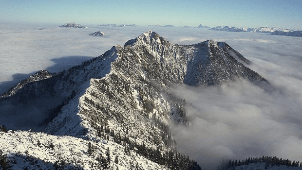
While travelling in the extreme west side of the region you will reach the Ester Mountains. It is just at this spot that the Bavarian Prealps are able to reach heights of over 2000 metres whereas everywhere else they remain below that marker. However, there are some very impressive limestone cliffs that can be found in the range.
The Expanses
The German Alpine Club brought out a document titled as the Classification of the Eastern Alps, 1984. In this document the Bayerische Voralpen has been defined in the following terms:
The pre-alps region begins right from the Murnau and then travels further by travelling through Kochel am See, Bad Tölz and finally reaches Rosenheim. Then it extends from the Inn and goes up to Kiefersfelden, Kieferbach, Glemmbach, Ellbach, Kaiserhaus, Brandenberger Ache, Erzherzog-Johann-Klause, Sattelbach, Ampelsbach, Achenbach, Walchen, and Isar. From this point onwards it also reaches Krün, Kranzbach, Kankerbach, Garmisch-Partenkirchen and finally from Loisach right up to Murnau.
The Subdivisions of the range
The Easter Mountains formulate the extreme western extension of the Bavarian Pre-alps which also is inclusive of the highest peak of the range. Furthermore, the highest peak of the range is known as Krottenkopf and it measures a height of 2,086 metres or 6,844 ft. Therefore, it features as the highest peak of both, the Easter Mountains and the Bavarian Pre-alps. Now, as far as the northern extents of the pre-alps is concerned, it is bordered by the Alpine Forelands.
The enclosure on the north-eastern end of the pre-alps is formed by Herzogstand and Heimgarten. There is also the long ridge if the Benediktenwand. The proper eastern section is then surrounded by the rivers – Isar and Inn. From here on both these rivers along with their smaller streams, namely Rottach, Weißach, Schlierach and Leitzach converge and form the Mangfall River. The mountainous region which develops ahead from the Mangfall River is known as the Mangfall Mountains. Also, most of the water from the groundwater storage that the above mentioned drainage creates serves as the primary water source for the city of Munich. Another mountain that is worthwhile scaling in the eastern section is the Hinteres Sonnwendjoch. This mountain is just below 2000 metres tall, measuring an exact height of 1,986 metres or 6,516 ft. above the sea level.
There is no dearth of scope for adventure seekers. Mountaineers and explores flock here in this region each year and majorly go on scaling the following neighbouring mountains of the regions:
- Chiemgau Alps: It is located further in the east,
- Kaiser Mountains: It is located in the south-eastern section of the region,
- Brandenberg Alps: Can be reached while travelling in the south,
- Karwendel: Another mountain located in the south,
- Wetterstein mountains: Located in the southwestern section of the region,
- Ammergau Alps: The must scale mountain in the west.
The Alpine Foreland
It is also otherwise known as the Bavarian Foreland, Bavarian Plateau or Bavarian Alpine Foreland. Locally in the German language the region is referred to as the Bayerisches Alpenvorland.
The Bavarian Foreland has a triangulated structure which then becomes a part of the plateau along with the rolling foothills in southern Germany. These Forelands in-fact stretch from their western end which is Lake Constance and then goes further in the east beyond Linz which is located on the Danube. The Bavarian Alps form its boundaries in the south and river Danube in the north.
Another piece of advice that one must follow is that quite often people also straightaway get confused between the Bavarian prealps and the Alpine Foreland. You just might find people who instead of classifying the prealps separately would term the entire region as Alpine Foreland. But, that is not the case the prealps definitely touch the forelands but are not a singular entity.
Tourism in the region
The Bayerische Voralpen is a hotspot in term of tourism. The region offers everything that one might require.
Precisely for this reason many of the peaks in the region cumulatively form a part of the ‘Home Mountains’ or ‘Munich’s Hausbergen’. All the mountains through are challenging in their own right but can be climbed throughout the year just on foot. Of-course that does not mean that one has to go without any preparation. It is an imperative that you remember that it is a glacial region after all. There is going to be so much snow that it is simply hard to imagine, one must see it to believe.
Moreover, whenever you get tired of looking at all the snow, you might as well turn around and explore the numerous other scenic sites. The region is really well protected and once in a while you will see patrols combing the area. In the case of the climbing routes, they are properly defined and marked distinctly marked. So, do not try hard to get lost, because it will in any case be difficult. But, remember irrespective of the time of the year, you must be careful at all costs.
If hiking is of your interest, in that case there are numerous long-distance hiking trails that will definitely help you getting that adrenalin kick. Additionally, these trails can extend very far and you might just be able to cover the Alps in its entirety. In the same regard, one must be familiar with the Via Alpina route.
What is the Via Alpina?
It is a system of about 5 long-distance hiking trails which run across the Alpine region which further include – Slovenia, Austria, Germany, Liechtenstein, Switzerland, Italy, France, and Monaco. The longest among this network is the red trail. It stretches between Trieste and Monaco.
Interestingly, the Via Alpina is quite new. It was created in the year 2000 by an association that included private and public organisations. Moreover, they also received funding from the European Union and a lot of support from the Grande Traversée des Alpes in Grenoble. Today, this trail is protected by the International Commission for the Protection of the Alps (CIPRA) which is located in Liechtenstein.
Here is the most hard-core fun that any individual can ever have. Beginning from the Bayerische Voralpen itself, the Via Alpina is one road that everyone must take. The following is a detailed list which covers each and every spot that you will cover while travelling on the listed 5 routes of the trail.
- The Purple Trail
A1: From Tržaška koča na Doliču to Aljažev dom v Vratih.
A2: From Aljažev dom v Vratih to Dovje.
A3: From Dovje to Koča na Golici.
A4: From Koča na Golici to Prešernova koča na Stolu.
A5: From Prešernova koča na Stolu to Roblekov Dom.
A6: From Roblekov Dom to Koča na Dobrči.
A7: From Koča na Dobrči to Tržič.
A8: From Tržič to Dom pod Storžičem.
A9: From Dom pod Storžičem to Zgornje Jezersko.
A10: From Zgornje Jezersko to Eisenkappler Hütte.
A11: From Eisenkappler Hütte to Riepl.
A12: From Riepl to Bleiburg.
A13: From Bleiburg to Lavamünd.
A14: From Lavamünd to Soboth.
A15: From Soboth to Eibiswald.
A16: From Eibiswald to Schwanberger-Brendlhütte.
A17: From Schwanberger-Brendlhütte to Koralpenhaus.
A18: From Koralpenhaus to Pack.
A19: From Pack to Salzstiegelhaus.
A20: From Salzstiegelhaus to Gaberl.
A21: From Gaberl to Knittelfeld.
A22: From Knittelfeld to Ingering II.
A23: From Ingering II to Trieben.
A24: From Trieben to Admont.
A25: From Admont to Spital am Pyhrn.
A26: From Spital am Pyhrn to Zellerhütte.
A27: From Zellerhütte to Hinterstoder.
A28: From Hinterstoder to Prielschutzhaus.
A29: From Prielschutzhaus to Pühringer Hütte.
A30: From Pühringer Hütte to Loserhütte.
A31: From Loserhütte to Bad Goisern.
A32: From Bad Goisern to Gosau.
A33: From Gosau to Theodor-Körner Hütte.
A34: From Theodor-Körner Hütte to Lungötz.
A35: From Lungötz to Werfen.
A36: From Werfen to Arthur Haus.
A37: From Arthur Haus to Erichhütte.
A38: From Erichhütte to Maria Alm.
A39: From Maria Alm to Riemannhaus.
A40: From Riemannhaus to Kärlingerhaus.
A41: From Kärlingerhaus to Königssee.
A42: From Königssee to Engedey.
A43: From Engedey to Neue Traunsteiner Hütte.
A44: From Neue Traunsteiner Hütte to Unken.
A45: From Unken to Ruhpolding.
A46: From Ruhpolding to Marquartstein.
A47: From Marquartstein to Kampenwand Bergstation.
A48: From Kampenwand Bergstation to Priener Hütte.
A49: From Priener Hütte to Spitzsteinhaus.
A50: From Spitzsteinhaus to Oberaudorf.
A51: From Oberaudorf to Brünnsteinhaus.
A52: From Brünnsteinhaus to Rotwandhaus.
A53: From Rotwandhaus to Sutten.
A54: From Sutten to Kreuth.
A55: From Kreuth to Lenggries.
A56: From Lenggries to Tutzinger Hütte.
A57: From Tutzinger Hütte to Herzogstand.
A58: From Herzogstand to Weilheimer Hütte.
A59: From Weilheimer Hütte to Garmisch-Partenkirchen.
A60: From Garmisch-Partenkirchen to Linderhof.
A61: From Linderhof to Kenzenhütte.
A62: From Kenzenhütte to Füssen.
A63: From Füssen to Pfronten.
A64: From Pfronten to Tannheim.
A65: From Tannheim to Prinz-Luitpold-Haus.
A66: From Prinz-Luitpold-Haus to Oberstdorf.
- The Yellow Trail
B1: From Muggia (Trieste) to Rifugio Premuda.
B2: From Rifugio Premuda to Villa Opicina.
B3: From Villa Opicina.
B4: From Sistiana or Sesljan to Gorizia.
B5: From Gorizia to Castelmonte and Stara Gora.
B6: From Castelmonte and Stara Gora to Rif.
B7: From Rif. Casoni Solarie to Rif. G. Pelizzo.
B8: From Rif. G. Pelizzo to Montemaggiore.
B9: From Montemaggiore to Passo di Tanamea.
B10: From Passo di Tanamea to Resiutta.
B11: From Resiutta to Rifugio Grauzaria.
B12: From Rifugio Grauzaria to Tolmezzo.
B13: From Tolmezzo to Ovaro.
B14: From Ovaro to Sauris di Sotto.
B15: From Sauris di Sotto to Forni di Sopra.
B16: From Forni di Sopra to Rifugio Pordenone.
B17: From Rifugio Pordenone to Rifugio Padova.
B18: From Rifugio Padova to Rifugio P. Galassi.
B19: From Rifugio P. Galassi to Rif. Città di Fiume.
B20: From Rif. Città di Fiume to Pieve di Livinallongo.
B21: From Pieve di Livinallongo to Passo Pordoi.
B22: From Passo Pordoi to Rifugio Contrin.
B23: From Rifugio Contrin to Fontanazzo.
B24: From Fontanazzo to Rifugio Antermoia.
B25: From Rifugio Antermoia to Schlernhaus / Rifugio Bolzano.
B26: From Schlernhaus / Rifugio Bolzano to Bozen / Bolzano.
B27: From Bozen / Bolzano to Meraner Hütte / Rifugio Merano.
B28: From Meraner Hütte / Rifugio Merano to Hochganghaus / Rifugio del Valico.
B29: From Hochganghaus / Rifugio del Valico to Jausenstation Patleid.
B30: From Jausenstation Patleid to Karthaus / Certosa.
B31: From Karthaus / Certosa to Similaunhütte / Rifugio Similaun.
B32: From Similaunhütte / Rifugio Similaun to Vent, Austria (de).
B33: From Vent to Zwieselstein.
B34: From Zwieselstein to Braunschweiger Hütte.
B35: From Braunschweiger Hütte to Wenns.
B36: From Wenns to Zams am Inn.
B37: From Zams am Inn to Memminger Hütte.
B38: From Memminger Hütte to Holzgau.
B39: From Holzgau to Kemptner Hütte.
B40: From Kemptner Hütte to Oberstdorf.
- The Green Trail
C1: From Sücka to Vaduz.
C2: From Vaduz to Sargans.
C3: From Sargans to Elm.
C4: From Elm to Linthal.
C5: From Linthal to Urnerboden.
C6: From Urnerboden to Altdorf.
C7: From Altdorf to Engelberg.
C8: From Engelberg to Meiringen.
C9: From Meiringen to Grindelwald.
C10: From Grindelwald to Lauterbrunnen.
C11: From Lauterbrunnen to Griesalp.
C12: From Griesalp to Kandersteg.
C13: From Kandersteg to Adelboden.
C14: From Adelboden to Lenk.
- The Blue Trail
D1: From Riale to Alpe Vannino.
D2: From Alpe Vannino to Alpe Devero.
D3: From Alpe Devero to Binn.
D4: From Binn to Rosswald.
D5: From Rosswald to Simplonpass.
D6: From Simplonpass to Zwischbergen.
D7: From Zwischbergen to Alpe il Laghetto.
D8: From Alpe il Laghetto to Rifugio Andolla.
D9: From Rifugio Andolla to Antronapiana.
D10: From Antronapiana to Madonna della Gurva.
D11: From Madonna della Gurva to Campello Monti.
D12: From Campello Monti to Santa Maria di Fobello.
D13: From Santa Maria di Fobello to Carcoforo.
D14: From Carcoforo to Rifugio Ferioli.
D15: From Rifugio Ferioli to S. Antonio di Valvogna.
D16: From S. Antonio di Valvogna to Gressoney-Saint-Jean.
D17: From Gressoney-Saint-Jean to Piedicavallo.
D18: From Piedicavallo to Issime.
D19: From Issime to Challand-Saint-Victor.
D20: From Challand-Saint-Victor to Covarey.
D21: From Covarey to Rifugio Dondena.
D22: From Rifugio Dondena to Alpe Péradza.
D23: From Alpe Péradza to Piamprato.
D24: From Piamprato to Tallorno.
D25: From Tallorno to Ronco Canavese.
D26: From Ronco Canavese to Talosio.
D27: From Talosio to San Lorenzo.
D28: From San Lorenzo to Ceresole Reale.
D29: From Ceresole Reale to Pialpetta.
D30: From Pialpetta to Balme.
D31: From Balme to Usseglio.
D32: From Usseglio to Rifugio Riposa.
D33: From Rifugio Riposa to Rifugio Stellina.
D34: From Rifugio Stellina to Refuge du Petit Mont Cenis.
D35: From Refuge du Petit Mont Cenis to Rifugio Vaccarone.
D36: From Rifugio Vaccarone to Rifugio Levi-Molinari.
D37: From Rifugio Levi-Molinari to Rifugio D. Arlaud.
D38: From Rifugio D. Arlaud to Usseaux.
D39: From Usseaux to Balsiglia.
D40: From Balsiglia to Ghigo di Prali.
D41: From Ghigo di Prali to Rifugio Lago Verde.
D42: From Rifugio Lago Verde to Le Roux.
D43: From Le Roux to Rifugio W. Jervis.
D44: From Rifugio W. Jervis to Rifugio Barbara Lowrie.
D45: From Rifugio Barbara Lowrie to Pian del Re.
D46: From Pian del Re to Refuge du Viso.
D47: From Refuge du Viso to Rifugio Savigliano.
D48: From Rifugio Savigliano to Chiesa di Bellino.
D49: From Chiesa di Bellino to Serre di Val d’Elva.
D50: From Serre di Val d’Elva to Ussolo.
D51: From Ussolo to Chiappera.
D52: From Chiappera to Larche.
D53: From Larche to Bousiéyas.
D54: From Bousiéyas to St-Etienne-de-Tinée.
D55: From St-Etienne-de-Tinée to Roya.
D56: From Roya to Refuge de Longon.
D57: From Refuge de Longon to St Sauveur-sur-Tinée.
D58: From St Sauveur-sur-Tinée to St-Martin-Vésubie.
D59: From St-Martin-Vésubie to Belvédère.
D60: From Belvédère to Col de Turini.
D61: From Col de Turini to Sospel.
- The Red Trail
R1: From Muggia to Rifugio Premuda.
R2: From Rifugio Premuda to Matavun.
R3: From Matavun to Razdrto.
R4: From Razdrto to Predjama.
R5: From Predjama to Črni vrh.
R6: From Črni vrh to Idrija.
R7: From Idrija to Planinska koča na Ermanovcu.
R8: From Planinska koča na Ermanovcu to Porezen.
R9: From Porezen to Črna prst.
R10: From Črna prst to Dom na Komni.
R11: From Dom na Komni to Koča pri Triglavskih jezerih.
R12: From Koča pri Triglavskih jezerih to Tržaška koča na Doliču.
R13: From Tržaška koča na Doliču to the Trenta Valley.
R14: From Trenta to Dom v Tamarju.
R15: From Dom v Tamarju to Thörl-Maglern.
R16: From Thörl-Maglern to Feistritzer Alm.
R17: From Feistritzer Alm to Egger Alm.
R18: From Egger Alm to Naßfeld.
R19: From Naßfeld to Zollnersee Hütte ehm. Dr. Steinwender Hütte.
R20: From Zollnersee Hütte ehm. Dr. Steinwender Hütte to Untere Valentinalm.
R21: From Untere Valentinalm to Wolayersee Hütte.
R22: From Wolayersee Hütte to Hochweißsteinhaus.
R23: From Hochweißsteinhaus to Neue Porze Hütte.
R24: From Neue Porze Hütte to Obstansersee Hütte.
R25: From Obstansersee Hütte to Sillianer Hütte.
R26: From Sillianer Hütte to Drei-Zinnen-Hütte.
R27: From Drei-Zinnen-Hütte to Dürrensteinhütte.
R28: From Dürrensteinhütte to Seekofelhütte.
R29: From Seekofelhütte to St. Martin in Gsies.
R30: From St. Martin in Gsies to Antholz-Mittertal.
R31: From Antholz-Mittertal to Rieserfernerhütte.
R32: From Rieserfernerhütte to Ahornach.
R33: From Ahornach to Chemnitzer Hütte.
R34: From Chemnitzer Hütte to Dun.
R35: From Dun to Pfitscherjoch.
R36: From Pfitscherjoch to Ginzling.
R37: From Ginzling to Finkenberg.
R38: From Finkenberg to Rastkogelhütte.
R39: From Rastkogelhütte to Loassattel.
R40: From Loassattel to Schwaz.
R41: From Schwaz to Lamsenjochhütte.
R42: From Lamsenjochhütte to Falkenhütte.
R43: From Falkenhütte to Scharnitz.
R44: From Scharnitz to Meilerhütte.
R45: From Meilerhütte to Reintalanger Hütte.
R46: From Reintalanger Hütte to Coburger Hütte.
R47: From Coburger Hütte to Wolfratshauser Hütte.
R48: From Wolfratshauser Hütte to Weißenbach am Lech.
R49: From Weißenbach am Lech to Prinz-Luitpold-Haus.
R50: From Prinz-Luitpold-Haus to Oberstdorf.
R51: From Oberstdorf to Mindelheimerhütte.
R52: From Mindelheimerhütte to Schröcken.
R53: From Schröcken to Buchboden.
R54: From Buchboden to St. Gerold.
R55: From St. Gerold to Feldkirch.
R56: From Feldkirch to Gafadurahütte.
R57: From Gafadurahütte to Sücka.
R58: From Sücka to Pfälzerhütte.
R59: From Pfälzerhütte to Schesaplana Hütte.
R60: From Schesaplana Hütte to Carschinahütte.
R61: From Carschinahütte to St. Antönien.
R62: From St. Antönien to Gargellen.
R63: From Gargellen to Tübinger Hütte.
R64: From Tübinger Hütte to Madlener Haus.
R65: From Madlener Haus to Jamtalhütte.
R66: From Jamtalhütte to Scuol.
R67: From Scuol to S-charl.
R68: From S-charl to Taufers.
R69: From Taufers to Stilfs.
R70: From Stilfs to Stilfser Joch.
R71: From Stilfser Joch to Arnoga.
R72: From Arnoga to Eita.
R73: From Eita to Malghera.
R74: From Malghera to Rifugio Schiazzera.
R75: From Rifugio Schiazzera to Tirano.
R76: From Tirano to Poschiavo.
R77: From Poschiavo to Rifugio Zoia.
R78: From Rifugio Zoia to Chiareggio.
R79: From Chiareggio to Maloja.
R80: From Maloja to Juf.
R81: From Juf to Innerferrera.
R82: From Innerferrera to Isola.
R83: From Isola to Pian San Giacomo.
R84: From Pian San Giacomo to Selma.
R85: From Selma to Capanna Alpe Cava.
R86: From Capanna Alpe Cava to Biasca.
R87: From Biasca to Capanna d’Efra.
R88: From Capanna d’Efra to Sonogno.
R89: From Sonogno to Prato Sornico.
R90: From Prato Sornico to Fontana.
R91: From Fontana to Robiei.
R92: From Robiei to Riale.
R93: From Riale to Ulrichen.
R94: From Ulrichen to Fieschertal.
R95: From Fieschertal to Riederalp.
R96: From Riederalp to Mund.
R97: From Mund to Gampel.
R98: From Gampel to Leukerbad.
R99: From Leukerbad to Schwarenbach.
R100: From Schwarenbach to Adelboden.
R101: From Adelboden to Lenk.
R102: From Lenk to Lauenen.
R103: From Lauenen to Gsteig.
R104: From Gsteig to Godey.
R105: From Godey to Anzeindaz.
R106: From Anzeindaz to Col du Demècre.
R107: From Col du Demècre to Vernayaz.
R108: From Vernayaz to Cabane de Susanfe.
R109: From Cabane de Susanfe to Refuge Tornay-Bostan.
R110: From Refuge Tornay-Bostan to Salvagny.
R111: From Salvagny to Refuge de Moëde-Anterne.
R112: From Refuge de Moëde-Anterne to La Flégère.
R113: From La Flégère to Trient.
R114: From Trient to Champex.
R115: From Champex to Bourg-St-Pierre.
R116: From Bourg-St-Pierre to Col du Grand-Saint-Bernard.
R117: From Col du Grand-Saint-Bernard to Cérellaz.
R118: From Cérellaz to Valgrisenche.
R119: From Valgrisenche to Refuge de l’Archeboc.
R120: From Refuge de l’Archeboc to Le Monal.
R121: From Le Monal to Le Lac de Tignes.
R122: From Le Lac de Tignes to Refuge de La Leisse.
R123: From Refuge de La Leisse to Termignon-la-Vanoise.
R124: From Termignon-la-Vanoise to Modane.
R125: From Modane to Granges de la Vallée Etroite.
R126: From Granges de la Vallée Etroite to Névache.
R127: From Névache to Le Monêtier-les-Bains.
R128: From Le Monêtier-les-Bains to Vallouise.
R129: From Vallouise to Freissinières.
R130: From Freissinières to Mont-Dauphin.
R131: From Mont-Dauphin to Refuge de Furfande.
R132: From Refuge de Furfande to Ceillac.
R133: From Ceillac to Maljasset.
R134: From Maljasset to Chiappera.
R135: From Chiappera to Chialvetta.
R136: From Chialvetta to Pontebernardo.
R137: From Pontebernardo to Rifugio Zanotti.
R138: From Rifugio Zanotti to Strepeis.
R139: From Strepeis to Sant’Anna di Vinadio.
R140: From Sant’Anna di Vinadio to Rifugio Malinvern.
R141: From Rifugio Malinvern to Rifugio Questa.
R142: From Rifugio Questa to Rifugio Morelli-Buzzi.
R143: From Rifugio Morelli-Buzzi to Rifugio Ellena-Soria.
R144: From Rifugio Ellena-Soria to Refuge de la Madone de Fenestre.
R145: From Refuge de la Madone de Fenestre to Refuge de Nice.
R146: From Refuge de Nice to Refuge de Valmasque.
R147: From Refuge de Valmasque to Castérino.
R148: From Castérino to Limonetto.
R149: From Limonetto to Rifugio Garelli.
R150: From Rifugio Garelli to Rifugio Mongioie.
R151: From Rifugio Mongioie to Ormea.
R152: From Ormea to Garessio.
R153: From Garessio to Caprauna.
R154: From Caprauna to Colle di Nava.
R155: From Colle di Nava to Colle San Bernardo di Mendatica.
R156: From San Bernardo di Mendatica to Colla Melosa.
R157: From Colla Melosa to Saorge.
R158: From Saorge to Breil-sur-Roya.
R159: From Breil-sur-Roya to Sospel.
R160: From Sospel to Peillon.
R161: From Peillon to Monaco – Place du Palais.