Allgäu: Adventure Begins Here
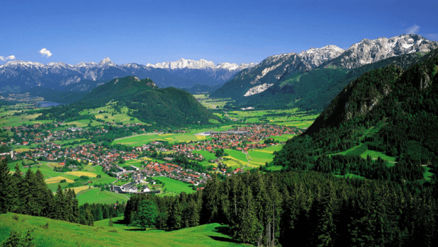
The Allgäu is a landscape which is located in the southern part of Germany. It forms a geographic sub-region of Upper Swabia, simultaneously including the south of Bavarian Swabia, southeastern part of Baden-Württemberg and also some parts of Austria. The Greater part of Allgäu falls within the German territory in the form of Allgäu Alps.
The region forms a very popular holiday spot most of which is known as the Allgäu Alps. However, the entire southern portion, which is proportionately half in size of the region, is located within the Austrian territory. Most of the Allgäu region, in any case, falls within German territory and ergo the Allgäu Alps as well. However, one does find numerous discrepancies concerning the territorial integrity of various border towns. The complexities were resolved when it came to the context of tourism and administrative purposes. Therefore, the names of certain districts were changed. For instance, take the example of districts such as – Oberallgäu, Ostallgäu and Unterallgäu. Particularly these districts were analogous to the regions of Lower and Upper Franconia.
In popularity terms, Allgäu is the best-known place in the whole of Germany. Annually, the region receives millions of tourists. The most attractive feature of the region is Alpine Sortings. Allgäu in fact is best known as a winter sporting centre. You can find some of the most well prepared cross-country skiing and skate tracks here.
The question of Origin
Allgäu, the name, as per a certain theory originated from the Old High German dialect wherein it means – mountain or a meadow. Going a little further in history, in the Middle High German language the prefix – gäu was figuratively indicative of an area or a landscape and also otherwise is used in reference to a dominion. Additionally, the colloquial usage of the complete word started to get enhanced, the cumulative word, that is Allgäu, it started to mean a mountainous landscape which further has numerous water sources, meadows and or pastures.
Geology of Allgäu
The geological development of the landscape began somewhere around 200 million years ago. It is at that point in time that the various mountains along with the formative structures of the range were created. These structures were a result of a supermassive tectonic plate shake which occurred in the mantle. Due to the immense thrust, the Alps began to protrude on the surface from the primordial ocean called Tethys. The Allgäu Alps comprise of different kinds of sedimentary rocks which carry features of the Mesozoic era.
The region between Lech and Lake Constance is occupied by a section of foothills which presents a stark contrast between the regions that are located near its two ends. These changes are characteristic of the last Ice Age which occurred some 20,000 years ago. Furthermore, these foothills were created out of the existing moraine mountains and hills. The abundance of moraines can be found in the Lech glacier region which is today found in Kaufbeuren which is further a subset of the Rhine glacier system. It is along this moraine rich mountainous terrain that the most popular and rather rare wells in lakes and fells can be encountered.
The regions of Allgäu
Allgäu within its confines does not have any form of geographical limitations. This partial region of the Upper Bavaria follows into an interestingly seamless merger with the nearby landscape, particularly in the northern and western regions. In the southern region of the landscape, the landscape is dominated by the Allgäu Alps. In its east lies the river Lech which performs a pivotal role in the daily functioning of the region.
The largest part of Allgäu occupies the region of Bavaria and followed by Baden-Wurttemberg, within the territory of Germany. Additionally, the bordering areas that fall in Austria and Kleinwalsertal also fall within the Allgäu. Furthermore, the division of the landscape of Allgäu can also be understood in terms of the various political partitions. In the same political instance, one tends to witness a great deal of disagreements especially pertaining to the neighbouring regions. However, the political paraphernalia is a great deal influenced by the needs arising out of tourism. No such administrative issue is allowed to attain an expanded state as keeping the standards of the brand Allgäu needs to be maintained.
The region’s current name that is – Allgäu was a result of the local government’s reforms that were created in the year 1973. Additionally, as far as the sub-regions are concerned, demarcation of their boundaries is blurred more often.
Following is a list of cities that can be found in the Allgäu region:
- Altusried
- Bad Hindelang
- Buchberg
- Blaichach
- Dietmannsried
- Durach
- Eisenberg (Allgäu)
- Fischen im Allgäu
- Fussen
- Haldenwang
- Immenstadt
- Isny
- Kaufbeuren
- Kempten (Allgäu)
- Kißlegg
- Leutkirch im Allgäu
- Lindenberg im Allgäu
- Marktoberdorf
- Nesselwang
- Obergünzburg
- Oberstaufen
- Oberstdorf
- Pfronten
- Rückholz
- Seeg
- Sonthofen
- Waltenhofen
- Wangen im Allgäu
- Weiler-Simmerberg
- Weitnau
- Wiggensbach
- Wildpoldsried
The highest peaks in the Allgäu Alps region include:
- Großer Krottenkopf: Measuring 2,657 metres, it falls within the region of Tyrol, and is a part of the Hornbach chain.
- Hohes Licht: It reaches a height of 2,652 metres and is located in the region of Tyrol, and is a part of the Main central chain.
- Hochfrottspitze: The Hochfrottspitze is 2,648.8 metres tall and stands tall within the regions of Bavaria and Tyrol, and is a part of the Main central chain.
- Mädelegabel: It measures a total of 2,644 metres in height and falls in between the Bavarian and Tyrol region alongside being a part of the Main central chain.
- Urbeleskarspitze: It reaches a length of 2,632 metres in the Tyrol Also, it is a part of the Hornbach chain.
- Steinschartenkopf: Measuring 2,615 metres in length, Steinschartenkopf is a part of the Main Central Chain and is located within the Tyrol region of Austria.
- Marchspitze: It is approximately 2,610 metres tall and a part of the Hornbach chain in the Austrian region.
- Bretterspitze: Bretterspitze reaches a height of 2,609 metres in the Tyrol region of Austria and is also a part of the Hornbach chain.
- Bockkarkopf: It is 2,608.5 metres in length and is located in between the regions of Bavaria and Tyrol at the same time being a part of the Main Central Chain.
- Biberkopf: It is roughly 2,599 metres tall and is a part of Bavaria and Tyrol, and is a part of the Main central chain.
Following is a list of the various scenic routes that should be on the must-experience list:
- German Alpine Road: It is often otherwise known as the cross Alpine road. The region holds exclusive scenic routes with respect to the Bavarian Alps. This route passes through Lake Constance. Furthermore, the road beginning close to Lindau am Bodensees and extends throughout the regions of Oberstaufen and then going past the Great Alpsee reaching Immenstadt and then further going through parts of Illertals to Sonthofen and it passes through the Valley of the Ostrach, finally reaching Bad Hindelang. From this point on it scales a height of 1178 metres above the sea level by crossing Oberjochpass and reaching Oberjoch. There onwards it branches to Unterjoch.
- The German Alpine Road also passes through Krün and Benediktbeuern to Bad Tolz along with Isartal to Sylvensteinsee. Here onwards, the road enters the Austrian territory. Its journey here is quite short and after two short rounds, it enters the Achen Pass which is located 941 metres above sea level. It again reaches a height of 1123 metres when it passes along Weißach, Rottach-Egern, Tegernsee, before descending into the Inn Valley. Before the road reaches a height of 793 metres at Maserer Pass it has already passed through Samerberg, Frasdorf, Aschau, Bernau and Grassau Marquartstein the Valley of the Tiroler Achen and Unterwössen.
- Mühlenstraße Oberschwaben: The Mill Street of Upper Swabia was established in the year 2005. Today about 100 shops are visibly in operation and sell products manufactured by them. A certain Elisabeth Jeggle had famously said that these mills together form the legacy of the Upper Swabian region, therefore they must be preserved. Furthermore, preservation is not just a matter of a day. On the other hand, it requires a long term, unceasing and tireless commitment.
The most popular of these mills can be listed as follows:
- Grinding mill in Dietenheim: It is a kind of water mill that was built on the medieval casting of the Iller. This setup dates back to the 16th century and it is equipped with wooden machinery from the 1950s.
- Machine Shop Schmid: This oil mill is located in Achstetten and was building back in the 18th century. It was later on converted into a mechanical workshop and today the mill also comprises of an overshot water wheel.
- Grave mill: Documents suggest that the first historical mention of the Grave Mill was way back in the year 1439. It was made in the context of Ochsenhausen, a Benedictine monastery. Later in the 18th century, the Grave Mill was expanded to also include a saw mill and further down, an oil mill. It is located in Berkheim –Eichenberg.
- Angermühle: It is located in Biberach and is considered to be one of the most historically significant mills. The Angermühle was constructed in the year 1293 and was considered to be one of the most important mills of the region for a very long time.
- Weißgerber Walkmühle: Situated in Biberach, the Weißgerber Walkmühle was built in the year 1699.
- Waterwheel Upper Mill: The Waterwheel Upper Mill is located in Biberach-Birkendorf. It was initially used as a power generator for the sawmill. Interestingly enough, the first mention of this mill in the historical documents was made in a document that dates back to the year 1350.
- Hammerschmiede in Blaubeuren: It was built as a grinding mill and Urban Waterworks in the year 1742 and is located on the Aachtopf.
- Danube weir and hydropower plant: It is located in Riedlingen and was constructed in the 15th century. This plant then went on to be developed as a small-scale hydroelectric plant. A model of this plant can be seen in the Schöne Stiege Museums rare testimonies of Wassermüllerei.
- Wimsener mill: This 14th-century mill is situated in Zwiefalten wherein it was developed as the official grinding mill of the monastery. It was later on adorned in the baroque architectural style of 18th century. Today, the mill features a permanent exhibition depicting the cave Wimsener and Minister of State Philipp Christian von Normann-Ehrenfels.
- Grain mill in Langenargen: It was built in the mid-16th century. The interior of this mill has been redesigned in such a manner that it appears as an exhibition depicting the turbine and a modern grinding system with old transmission technology since the 1900s.
- Nahmühle in Ertingen: It dates back to the year 1290 making it one of the oldest mills in the region. furthermore, the Nahmühle has been largely privately owned since the end of the Thirty Years War.
- Historical wind turbine: This famous mill converted into a museum is among the initial 30 former wind turbines. By the end of the 19th century, they were redesigned based on the American models known as – Halladay wind pumps in the Ravensburg district.
- Swabian Farm Museum: This famous mechanical workshop converted into a museum is located in Kronburg –Illerbeuren.
- Upper Swabian Baroque Route: This 500-kilometre long scenic route was launched in the year 1966. It is centrally located in the Upper Swabian region and passes along the numerous sacred buildings hailing from the Baroque period. Furthermore, the route also connects with the adjoining regions of Switzerland and the Austrian state of Vorarlberg. The sites that must be visited in this region are as follows:
- Laupheim along with the Parish Church of St. Peter and Paul and Schloss Laupheim must be visited.
- Biberach and the parish church of St. Martin.
- Ochsenhausen Monastery
- Gutenzell, it along with the former Gutenzell Abbey and Church of St. Cosmas and Damian.
- Steinhausen: It is regarded as the most beautiful village church in the world.
- Bad Schussenried
- Aulendorf along with the Castle and Parish Church of St. Martin.
- Obermarchtal: Along with the monastery of Münster, this entire complex is often called as the little Versailles.
- Bad Wurzach: It is a magnificent castle which has some of the most beautiful Baroque staircases in the world.
- Kressbronn am Bodensee.
- Tettnang or the New Castle comprises of a baroque palace known as Montfort.
- Langenargen: It is a baroque church.
- Friedrichshafen: It is located near Lake Constance along with the former Hofen monastery or the Castle Church.
- Ravensburg: Located in the Weißenau district.
- Weingarten: The complex comprises of a monastery and a basilica which houses the famous Gabler organ.
- Monastery Zwiefalten.
- Meßkirch: Here lies a Renaissance palace and a city church.
- Sigmaringen: One can also find the Sigmaringen Castle here.
- Ueberlingen: The most famous building located here is a medieval Münster.
- Meersburg: It is the oldest castle in Germany.
- Romantic Road: Located at the southern end of Allgäu, the Romantic Road is the oldest as well as the most popular holiday routes of Germany. It begins from the German city of Main and goes westwards while passing through Bavarian Swabia and finally reaches the Alps in Ostallgäu. The road passes through numerous historical landscapes such as Wurzburg , Rothenburg ob der Tauber , Dinkelsbühl, Nördlingen, Harburg, Donauwörth, Augsburg, Friedberg and Landsberg am Lech, and the Franconian Feet. Among the other sites that can be visited are: Tauber Valley, the Ries, the Lechrain and the entire alpine foothills around Landsberg am Lech.
- The Romantic Road was conceived in the 1950s while Germany was desperately trying to shed its World War II image and develop its many sites for the tourists. Among the first tourists who explored the region were the Americans who initially had come to occupy the region and would quite often vacation in the region. Additional changes were made in the routes in the year 2009, 2011, 2012 and 2016.
- Swabian spa Route: It is another tourist route in Southern Germany that connects the 9 spas and health resorts together. The route is approximately 180 kilometres and it covers the following destinations: Ueberlingen on Lake Constance on Bad Saulgau in the district of Sigmaringen, Bad Buchau and Bad Schussenried in the district Biberach, Aulendorf, Bad Waldsee and Bad Wurzach in district Ravensburg and Bad Grönenbach to Bad Wörishofen in Unterallgäu.
Regional Specialties
Traditionally speaking the regional cuisine of Allgäu pertains to the various ingredients that are abundantly and cheaply available in the surrounding area. It is so because of the various age of impoverishment that had inflicted the region once upon a time. Most of the popularly used ingredient of the cuisine is as follows: eggs, flour, milk, fat and sauerkraut and the various verities of the cottage garden. There are numerous kinds of herbs as well that are significantly used in the cuisine. Baked dishes are essentially quite popular along with other simply made ones that generally require low costing products but are rich in nutrients. Their examples are mentioned below:
- Pastries:
o Kässpatzen
o herb spaetzle
o Kratzat
o Schleifernudla: These hold similarity with noodles. The dough is prepared using dough from wheat flour.
o Tamper
- Desserts:
o Nonnafürzle: It is a golden brown and smaller in size. Teigknödel is another such variety.
o Boozy Virgin: It is prepared by frying in deep fat dough pieces, which are then doused with hot cider or wine.
- Various:
o Brenntar: It is also otherwise known as black-Mus and prepared using roasted potatoes.
o Katzegschrei.